
8.3 miles RT
Elevation gain: about 800 feet
I can't decide whether this loop goes better clockwise or counterclockwise. Not that it matters, as this is one fine introduction to ASS. You can always try it both ways.
From the car, take Forest Service Route 2 across the Chiwawa River bridge to Junction C (1.1 miles from the car), then another quarter mile to Route 6D. Turn right on 6D and climb as the trail wiggles its way above Alder Creek with pretty views of thinned forests and open vistas across the Chiwawa Valley. In 3.2 miles (4.5 from the car) you reach an intersection and have to make a choice. To the left is Route 6C, a pleasant stroll through forest until it takes a left turn and screams down to the valley floor in a hold-onto-your-cajones kind of way. If you don't need that particular adrenaline rush, turn right onto Route 6B for a more sane 1.5-mile downhill jaunt to Route 6. Turn left onto Route 6 back to Junction C. From here you can reverse the loop or head straight back to the car.
The Alder Ridge trail is one sweet introduction to ASS.
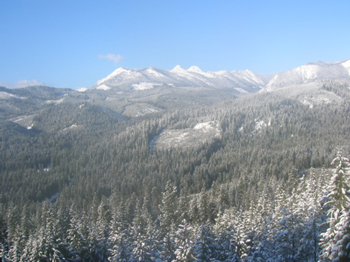
Views up the Chiwawa valley from Alder Ridge