
18 miles RT
Elevation gain: 2000 feet (high point 3750 feet)
Snowmobilers sometimes brag about the rush from riding their sleds up Pole Ridge to an area known as Sno-Cone. But they've got no idea. Pole Ridge is kick-A.S.S. skiing at its best. It takes you on a 4-mile uphill grunt that goes on forever, and then a 6-mile (mostly) downhill screamer that makes your heart pound even more. Do this route and you earn your official A.S.S. man or A.S.S. woman credentials. And, if some snowmobiler starts spouting off about Sno-Cone, savor the moment. Not only did you get up there on your own leg power, but (remembering A.S.S. Rule #1) you were there all alone on top of the ridge, with nothing but the sound of your skis sliding on perfect corduroy trails. That is, unless you count the sounds of your thumping heart or screaming lungs.
The route: From the sno-park, turn left onto what the Forest Service calls Route 3, toward Meadow Creek Campground (see Trip #1). After 2.4 miles of easy gliding, turn left onto (Forest Service) Route 4. The uphill starts immediately and does not let up for 4 miles. Actually, you reach another intersection within 0.5 miles, and you can bailout from the Pole Ridge commitment by turning right onto Valeria's Way Too – taking Jarrad's Loop (see Trip #7) in a clockwise direction.
But for Pole Ridge, kept left onto (Forest Service) Route 4B and keep climbing. In 2 miles you pass through a patch of private land. Off to the left is the driveway of the homeowner who rides a snowmobile down the hill in the morning to get to work. After the driveway the uphill eases off a bit. To the right the trees open up for occasioinal views up the Chiwawa River Valley to Red, Chiwawa, and Fortress Mountains. Stop to catch your breath and also peer down at the Meadow Creek valley bathed in green and white.
At 6.6 miles from the car you come to another intersection (Junction R). By this time you really are on Pole Ridge, with a views to the left down to Lake Wenatchee. This time, turn right onto Route 4C. (A left turn onto Route 4D takes you on the Ironman variation of the Pole Ridge trip, complete with something called the MF Hill. DO NOT go this way, unless your name is Eric Wehrly or Russell Cunningham. If you nonetheless insist on visiting the MF Hill, I describe the Ironman variation here).
Anyway, after turning right onto Route 4C, continue your uphill climb for another 0.8 mile to the high point of the trip at 3750 feet. There are still hills to climb ahead of you, but savor the expectation of adrenaline mega-doses as you carom down this mountain on your skinny skis. Hey, you don’t see any fixed heel, fat ski, big sidecut whusses getting any ASS.
There is another intersection as the Ironman variation (Route 4D) returns to the main route. Continue straight ahead onto Route 4F for some of the sweetest skiing you will ever know. I guarantee it.
Most of the next 5.3 miles is spent holding onto your cajones as you scream down the twisty trail. For extra excitement, try to avoid braking, stepping through each downhill curve (I can’t make it without hitting the brakes occasionally). Just don’t kill yourself, as that would give the sport a bad name.
After 5.3 miles of bliss it is time to return home. Turn right to join Jarrad's Loop (Trip #7) along Valaria's Way Too (Forest Service Route 4A). This is a beautiful up-and-down wander through forest that connects with Route 4. Now you retrace your tracks, turning left onto Route 4 and right onto Route 3 for the ride back to the car. Congratulations, you are now an Official ASS Woman (or Man).
[Ironman variation and the MF Hill – This is a worthy variation. Looking forward to the MF Hill is like looking forward to a root canal. It kicks my butt every time. Doesn't matter whether I am going up or down the darn thing.]
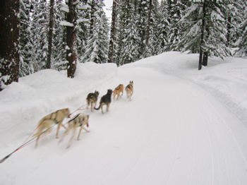
Running with the dogs near the top of Pole Ridge (this dog team was in the lead of the Cascade Quest)
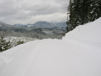
Near the top of Pole Ridge. Next: A 2000-foot drop on skinny skis